
(Updated 12:05 p.m.) The powerful typhoon coming
from the east intensified further and accelerated Sunday morning and may
enter the Philippine Area of Responsibility Sunday evening, state
weather forecasters said.
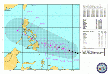
PAGASA said was estimated at 1,110 km east-southeast of Hinatuan, Surigao del Sur as of 10 a.m., and is now moving west-northwest at 22 kph.
"Estimated mamayang 8 p.m. papasok sa Philippine Area of Responsibility [PAR] sa may Palau area," National Disaster Risk Reduction and Management Council head Benito Ramos said in a news conference, parts of which were aired on dzBB radio.
Ramos said the PAR extends to parts of Palau, Taiwan and Sabah.
In its 11 a.m. advisory, PAGASA said the typhoon now packed maximum sustained winds of 185 kph near the center and gustiness of up to 220 kph.
The typhoon is to be locally codenamed "Pablo" once it enters the PAR.
PAGASA said the typhoon may bring rainfall of 20 to 30 mm per hour (heavy to intense) within its 700-km diameter.
By Monday morning, the typhoon is forecast to be 660 km east of Hinatuan, Surigao del Sur. By Tuesday morning it is expected to be 140 km east-notheast of Hinatuan or 230 km east-southeast of Surigao City.
On Wednesday morning, it is expected to be 60 km north of Dumaguete City.
But while PAGASA said the typhoon is still too far to directly affect any part of the country, it advised the public and the disaster coordinating councils concerned to take appropriate action.
On the other hand, PAGASA senior weather forecaster Roberto Sawi said that while the typhoon may possibly dissipate on Friday, it may still bring rain to parts of Southern Luzon and the rest of Luzon.
Typhoon path
As of 4 a.m. Sunday, the US Joint Typhoon Warning Center indicated the typhoon may pass through parts of Visayas and Mindanao and even Southern Luzon and Bicol from Dec. 4 to 6.
The Japan Meteorological Agency's 2:45 a.m. update indicated the typhoon will be "very strong," but may weaken to "strong" early Dec. 5.
Albay braces vs typhoon
Authorities in Albay are putting on hold the province's annual "Karangahan" month-long green Christmas festival and preparing a preemptive evacuation of residents instead, even as they continue to monitor developments in the approaching typhoon.
Governor Jose Salceda directed the month-long Karangahan Festival placed “on hold” starting December 4, according to a report on state-run Philippines News Agency Saturday.
The PNA report said a full-blown preemptive evacuation in some parts of the province is to start on Dec. 4. — ELR/LBG, GMA News
0 comments:
Post a Comment